Level before the water: five ground questions before a Jakarta house is designed
Before a Jakarta house is drawn: floor level against road and flood, subsidence at the address, rain on the plot, the soil, and what sits lowest.

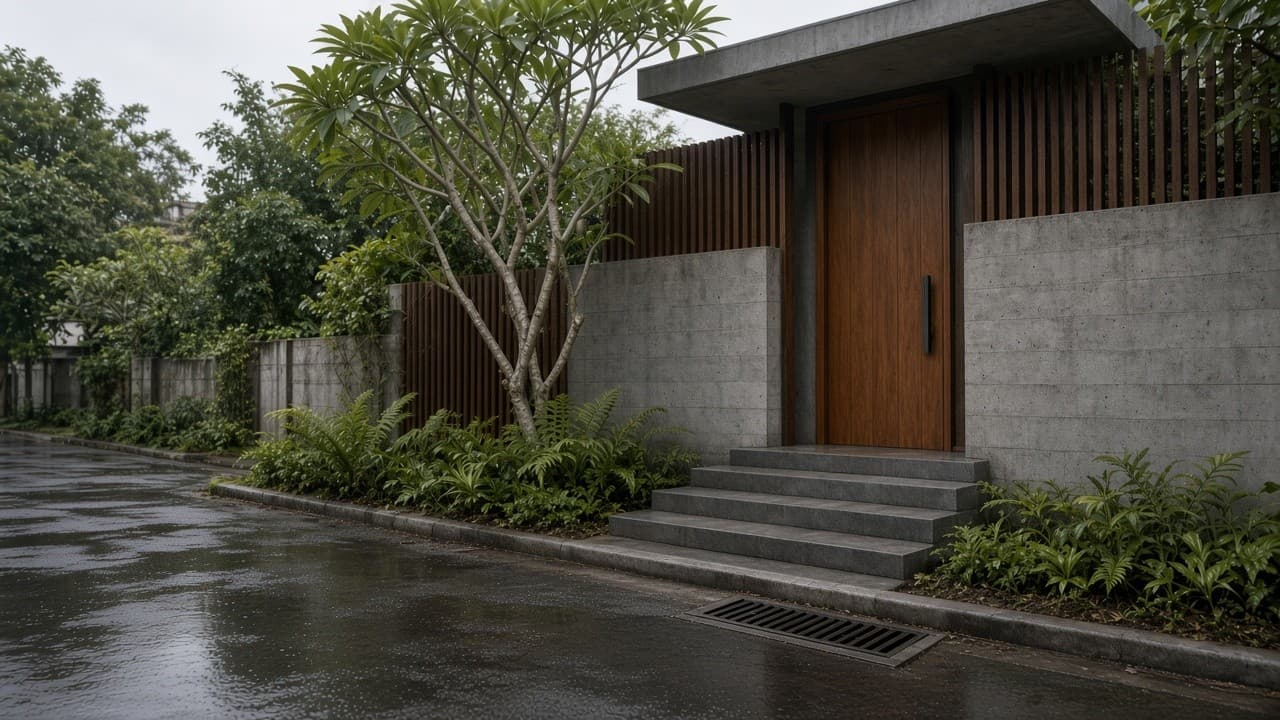
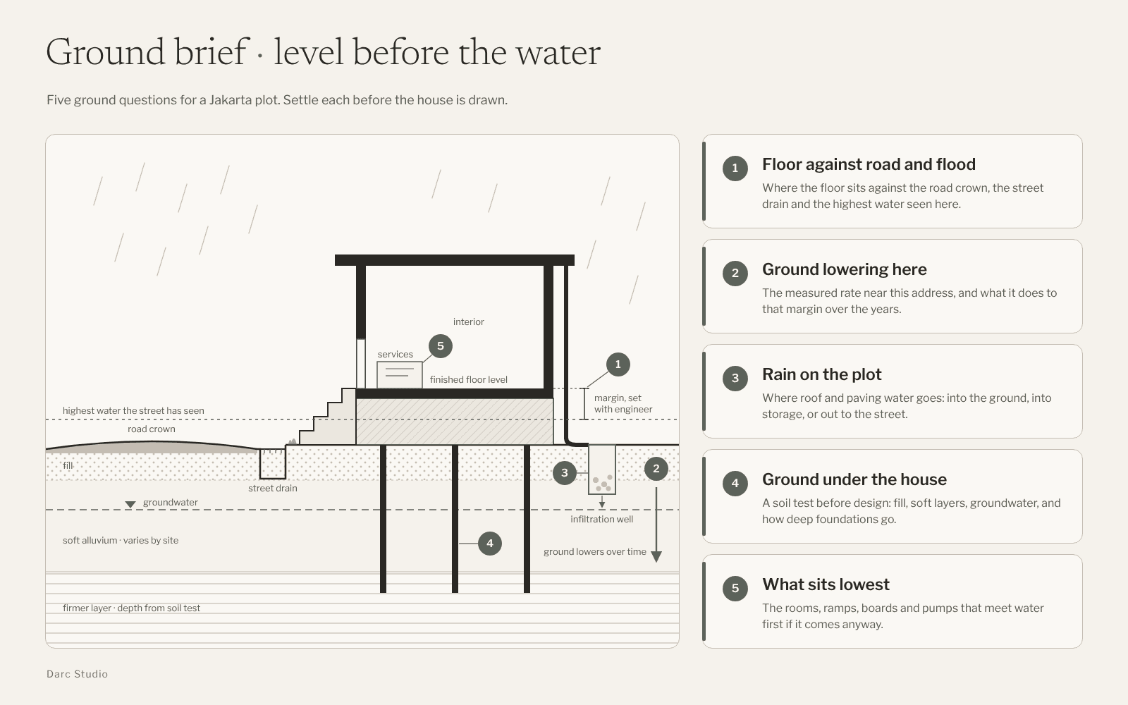
Before a Jakarta house is drawn, settle five things about its ground: where the finished floor will sit against the road and the highest water the street has seen, how fast the land at that address is going down, where rain landing on the plot will go, what the soil can carry, and what will sit lowest if water comes in anyway. These are survey and engineering answers. Put them on paper before anyone sketches a façade.
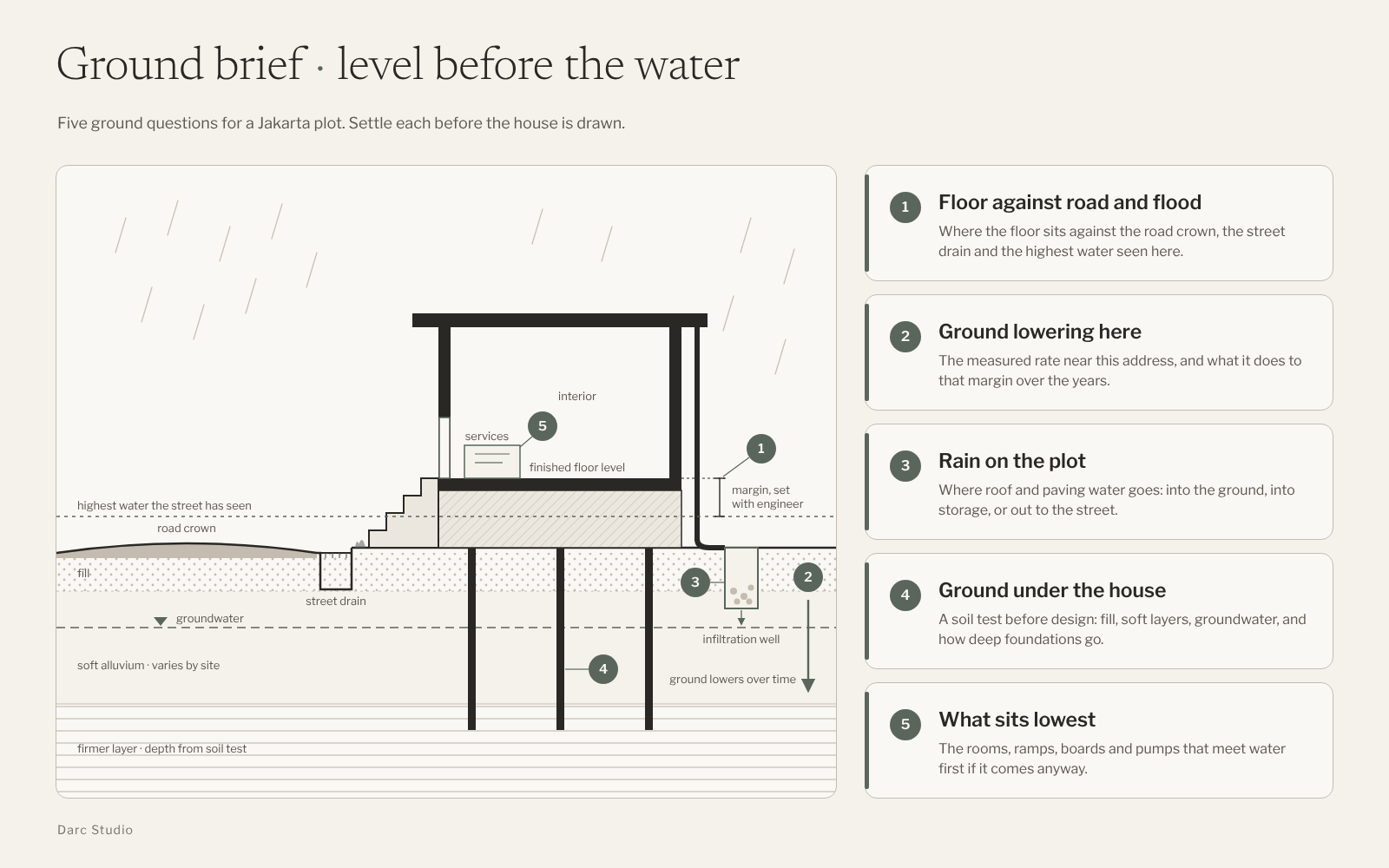
Editorial diagram. Five ground questions on a generic Jakarta plot section.
Why the ground comes first on a Jakarta plot
Jakarta floods street by street. On the night of 22 January 2026, BPBD DKI counted 132 RT under water; by the next morning it was 125 RT and 14 road sections across North, South, West and East Jakarta (ANTARA, 23 Jan 2026). On 5 May 2026, 80 RT were still flooded at 11:00, with water between 10 cm and 1 m after heavy rain and overflow from the Krukut, Grogol, Mampang, Angke, Pesanggrahan and Ciliwung rivers (detikNews, 5 May 2026). On 1 January 2020, BMKG measured 377 mm of rain at Halim Perdanakusuma, at the time the highest since measurements began in 1866 (Kompas, 3 Jan 2020).
The season is turning now. BMKG's Sestama Guswanto said the wet season would begin entering Jakarta in October 2026, with peak intensity in January and February 2027 (detikNews, 20 Sep 2026). Nationally, BMKG expects a very strong El Niño to last into early 2027 and the wet season to start later than normal across most of the country (BMKG, 2 Oct 2026). A seasonal outlook will not tell you how high water rises outside your gate. The five questions get closer.
This is for owners of a landed plot in Jakarta who have not yet briefed an architect, or who have a first sketch and no level survey. The answers shift with:
- Where the plot sits in the city, and how close it is to the north coast or a river
- Whether the plot is above or below the road in front
- What the street has flooded to before, and when
- What the soil is, and how near the surface groundwater sits
- Whether the brief includes a basement, a sunken garage, or a low garden room
Roofs, membranes and gutters are a separate brief, set out for Bali in Dry before the rain. This one stays at ground level.
The five ground questions
Put each answer on one page with its source: a survey, a soil test, a measurement, a dated account from a neighbour. A licensed surveyor, a geotechnical or structural engineer, and the architect each own part of it.
1. Floor level: where will the floor sit against the road and the highest water?
Ask: the level of the road crown in front of the plot, the street drain, the plot surface at each corner, and the highest water anyone has recorded or remembers on this street, with the date.
Why: A plot below the road collects the road's water as well as its own. The finished floor has to be set against measured levels, with a margin above the highest known water. That margin is a decision for you and your engineer, made with the survey in hand. We do not publish a standard figure, because it depends on the street, the plot, and the rate in question 2. BPBD DKI reports floods by kelurahan and RT, and the city runs the Pantau Banjir Jakarta portal. Ask your RT what those reports have said about your street.
Request:
- A level survey tied to the road crown, the street drain, and the plot corners
- Dated accounts of past floods from neighbours and the RT, with photos if they exist
- The flood depths BPBD has reported for your kelurahan in recent seasons
Common failure: Setting the floor by eye from the gate on a dry afternoon.
2. Subsidence: how fast is the ground at this address going down?
Ask: what the nearest measured subsidence rate is, who measured it, over which years, and whether the plot draws groundwater or will.
Why: Rates differ across the city and between studies, so ask for the figure measured nearest your plot. Badan Geologi's GPS monitoring for 2015 to 2023 found 0.05 to 5.17 cm a year and says the rate is levelling off (Tempo, 18 Dec 2025). Its groundwater conservation office, BKAT, measured 0.05 to 5.76 cm a year at 100 locations over 2015 to 2024, with the highest rates, above 4 cm, in Cengkareng Barat, Kedoya Selatan, Kalibaru and Penjaringan (Kompas, 7 Jan 2026). The city's water agency, Dinas SDA, reported an average of about 4 cm a year across 255 GPS points in 2023 and about 10 cm at Muara Baru. Its 2025 figures were about 5.5 cm in Pluit and 4.5 cm in Muara Angke (Dinas SDA, 12 Jun 2026). Earlier work by ITB's geodesy group recorded 1 to 15 cm a year between 1982 and 2010, and up to 20 to 28 cm in a few places (Abidin, Andreas et al., Natural Hazards, 2011).
Subsidence takes the plot, the house and the street down together, but not the sea or the rivers the drains run to. A floor that clears the street's flood mark today has less margin each year the ground goes down. Badan Geologi, BKAT and Dinas SDA all name groundwater extraction as a main cause. Pergub DKI 93/2021 has barred groundwater use since 1 August 2023 in listed zones for buildings of 5,000 m² of floor or more, or eight storeys or more. A typical landed house falls outside that test, but Dinas SDA consulted in April 2025 on extending the zones in North Jakarta (Dinas SDA, 25 Apr 2025). Where PAM Jaya piped water reaches the street, we would rather plan the house on it than on a new deep well.
Request:
- The nearest published subsidence measurement, with its source and years
- Whether the street sits in a Zona Bebas Air Tanah, or in a proposed extension
- Whether PAM Jaya piped water reaches the plot, and at what point
Common failure: Quoting one city-wide figure for a plot that sits in a faster- or slower-sinking part of Jakarta.
3. Rain on the plot: where will each storm's water go?
Ask: where rain from the roof and the paving goes: into the ground, into storage, or out to the street drain, and what happens when each of those is full.
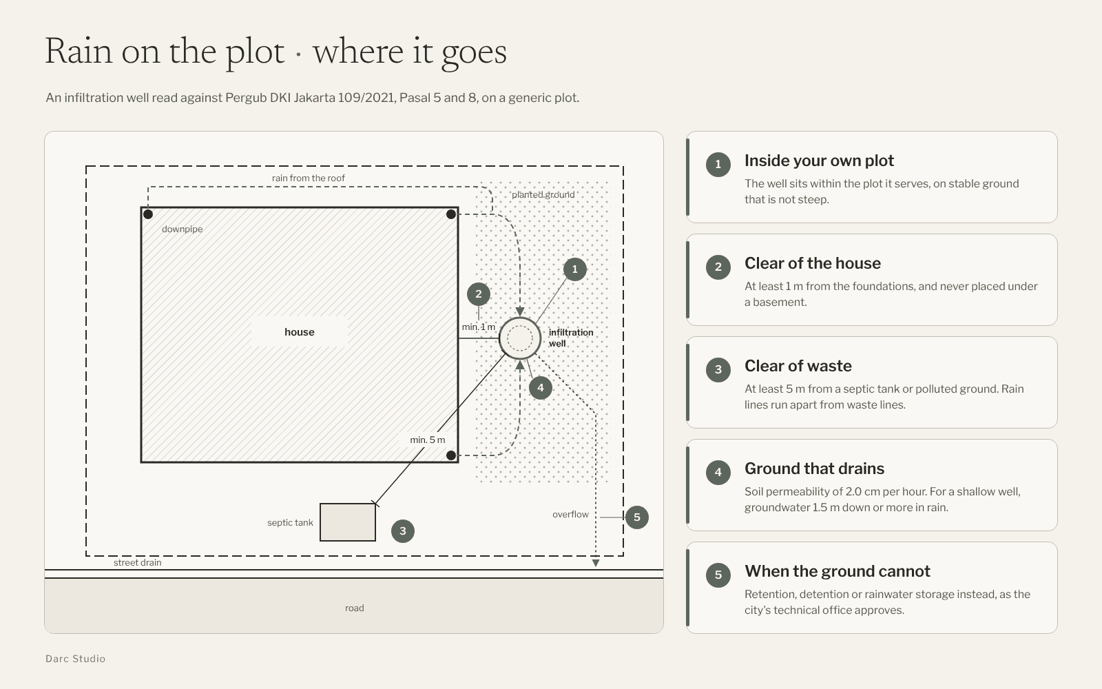
Why: National rules treat rain on a plot as something to use, soak into the ground, or hold back for a while, so that less of it reaches the city's drains at once (Permen PU 11/PRT/M/2014, in force). In Jakarta, Pergub DKI 20/2013 on infiltration wells, as amended by Pergub DKI 109/2021, requires owners of new and existing buildings to build a sumur resapan (infiltration well), an infiltration pond, or an approved substitute. Pasal 5 sets where a well may go: inside the plot, at least 1 m from the foundations, at least 5 m from a septic tank or polluted ground, never under a basement, and fed by drains kept apart from waste lines. The soil needs a permeability of 2.0 cm an hour, and for a shallow well groundwater must sit at least 1.5 m down during rain. Where the ground cannot meet those conditions and the technical office agrees, Pasal 8 allows retention, detention or rainwater storage instead. The well is drawn in the permit plans, and the SLF can be issued once it is built (Pasal 10 and 11).
Request:
- A soil permeability test and the wet-season groundwater level at the well location
- A plan with the well, the septic tank, the foundations and the overflow route drawn and dimensioned
- Whether the plan uses a well, a pond, or a substitute, and why
Common failure: Placing the well where it is convenient, beside the septic tank or under a basement added later.
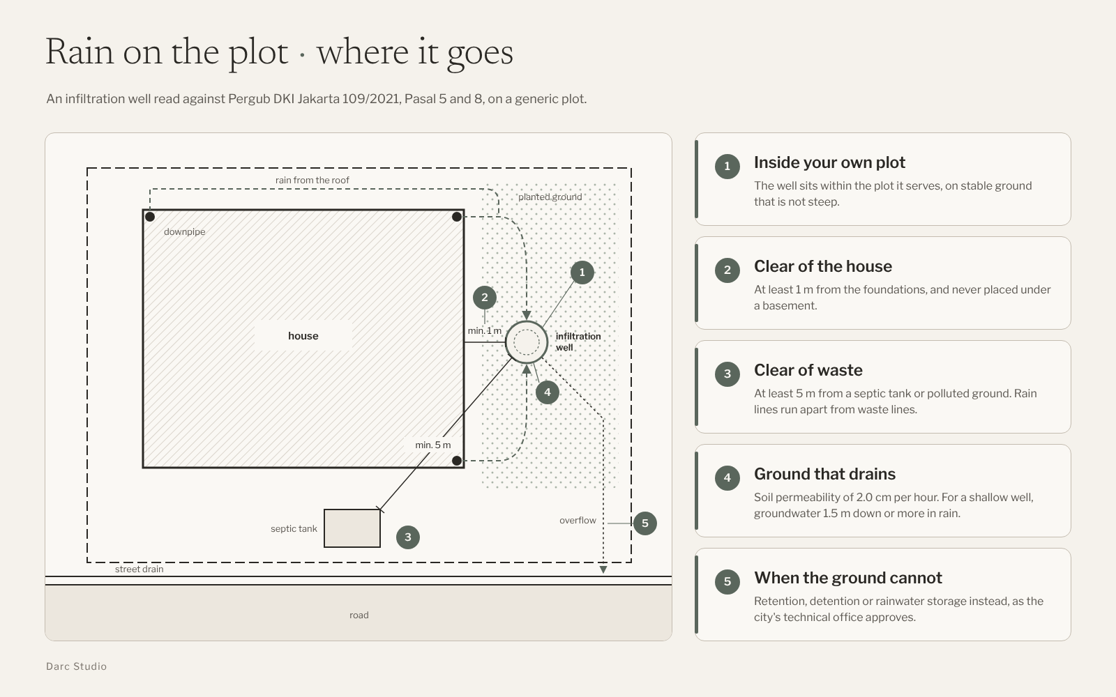
Editorial diagram. An infiltration well on a generic plot, read against the location rules in Pergub DKI 109/2021.
4. Ground and foundations: what is under the plot, and what can it carry?
Ask: what the soil is to the depth that matters, whether the plot was filled and when, how deep the soft layers go, where firmer ground starts, and where groundwater sits in wet and dry months.
Why: Badan Geologi names young sediment and soft soil among the causes of subsidence in Jakarta. The ITB study lists four causes, two of them in the ground itself: natural consolidation of the alluvium, and settlement of highly compressible soil under the load of buildings. Raising a low plot with fresh fill adds that kind of load. A soil investigation tells the engineer which foundation fits, and it belongs before the plan is fixed, because the foundation can change the plan. It also answers question 3: the same test shows whether a well will drain at all.
Request:
- A soil investigation with test locations marked on the plot, and the engineer's reading of it
- The history of any fill on the plot, from the seller or neighbours
- Where water that sits on the plot today will go once the plot is raised, including onto neighbouring plots
Common failure: Raising a plot with fill and designing on it before anyone has asked how the soil below will respond.
5. What sits lowest: if water comes in anyway, what meets it first?
Ask: which rooms, ramps, electrical boards, pumps, tanks and stored things will sit at the lowest level, and what happens to each of them in a flood.
Why: A margin lowers the odds of water getting in, without ruling it out. A basement or a carport ramp that falls from the road gathers street water by its shape, and Pergub 109/2021 does not allow an infiltration well under a basement. Dinas SDA notes that coastal residents have raised their homes in stages to cope with tidal flooding, and says that cannot be a permanent answer. A new house can decide once, on paper, what is allowed to sit low and what is not.
Request:
- A list of everything planned at or below ground-floor level
- Where pumps would discharge, and how the electrical supply is protected
- A walk through the plan imagining the street flooded to its highest recorded level
Common failure: Drawing a sunken garage or basement to win space on a small plot before anyone has checked the street's flood history.
How we read a Jakarta plot before drawing
We have no flood or subsidence case from our own work that we can publish, and we will not invent one.
What we can describe is the order we work in. We ask for a level survey that starts at the road crown. We ask the neighbours and the RT what the street has done in past floods, and when. We find the nearest subsidence measurement and note its year. We ask for a soil investigation before the plan is fixed. Then we draw the path of rain from roof to well to street on one page, and only after that do we set the floor with the engineer. Cipayung House, our 2016 design proposal for three terraced houses in Cipayung, is the kind of landed Jakarta brief these questions are written for.
What a higher floor asks of the rest of the house
A higher floor buys margin. It also asks for more steps or a longer ramp at the entry, more fill or a deeper structure under the ground floor, and a different relationship between the rooms, the garden and the street. Older family members will feel the steps every day. Raising the whole plot adds load to soft ground, as question 4 explains, and it can move water toward the neighbours.
A lower floor avoids those costs and accepts more risk, now and as the ground goes down. Neither is right for every street. The level survey, the subsidence figure and the soil test decide where on that range your house belongs.
No rupiah figure belongs here. The cost depends on the plot, the soil and the specification. For how premium build costs are put together, see What sits inside a premium Jakarta build cost.
Where Jakarta ground decisions go wrong
- Setting the floor level from the gate, without a survey tied to the road.
- Using one city-wide subsidence figure for a plot in a faster-sinking area.
- Treating the infiltration well as a box to tick at the end, with no soil test.
- Raising a plot with fill without asking where its water will go.
- Fixing the plan before the soil investigation, then finding the foundation does not fit it.
- Putting the electrical board, pumps or a basement at the lowest point because that is where space was left.
To bring to the first meeting
- Certificate of title, and any existing survey of the plot.
- A level survey tied to the road crown, the street drain and the plot corners.
- Dated accounts of past floods on the street, from neighbours, the RT and BPBD reports.
- The nearest published subsidence measurement, with source and years.
- Whether PAM Jaya water reaches the plot, and whether the street is in a groundwater-free zone or a proposed one.
- A soil investigation, or a plan to commission one before design.
- A list of anything the brief wants below or at ground level: basement, sunken garage, garden room.
If any of these are blank, the floor level is still a guess. When to bring in an architect at all is covered in When a premium residence needs an architect.
Set the floor once
Set the floor once, against measured levels, and the rest of the house can be designed around it. This is a set of questions, not engineering or legal advice. Confirm each one for your plot with the surveyor, engineer and permit specialist licensed to answer it.
“A floor that clears the street's flood mark today has less margin each year the ground goes down.”